North Carolina - 39.1 Mile AT Section Hike
- Jerry Caldwell

- Jul 26, 2020
- 5 min read
Updated: Mar 15, 2021
Appalachian Trail Section Hike - 39.1 miles
North Carolina & Tennessee: Clingman’s Dome, NC to Davenport Gap, TN
23 July to 26 July, 2020
NoBo. Two hikers. View the hike on YouTube
“Due to aggressive bear activity, this shelter is closed.”
This is how our plans were changed on us for night three. When planning a section hike, always be prepared to deviate from your plan.
Another great time on the Appalachian Trail with my hiking buddy longtime friend, Andy. Both Andy and I are section hikers. Andy was gracious enough to accompany me on a section he had previously completed. I was able to log another 39 miles on the AT during this trip, which allowed me to complete the Smoky Mountains portion of the AT. I had hiked from Fontana to Clingman’s back in 2017 - here is that trip report.
Note: For those who don’t know, you are required to obtain permits to hike the AT in the Smoky Mountains.
We parked at Big Creek Ranger Station at Davenport Gap, TN. Andy’s friend met us there and gave us a ride to Clingman’s Dome.
We logged 39 miles on the AT, but actually hiked around 45 miles due to shelters off the trail, two side journeys to Cammerer tower, and hiking on a hard surface road to get to our cars.

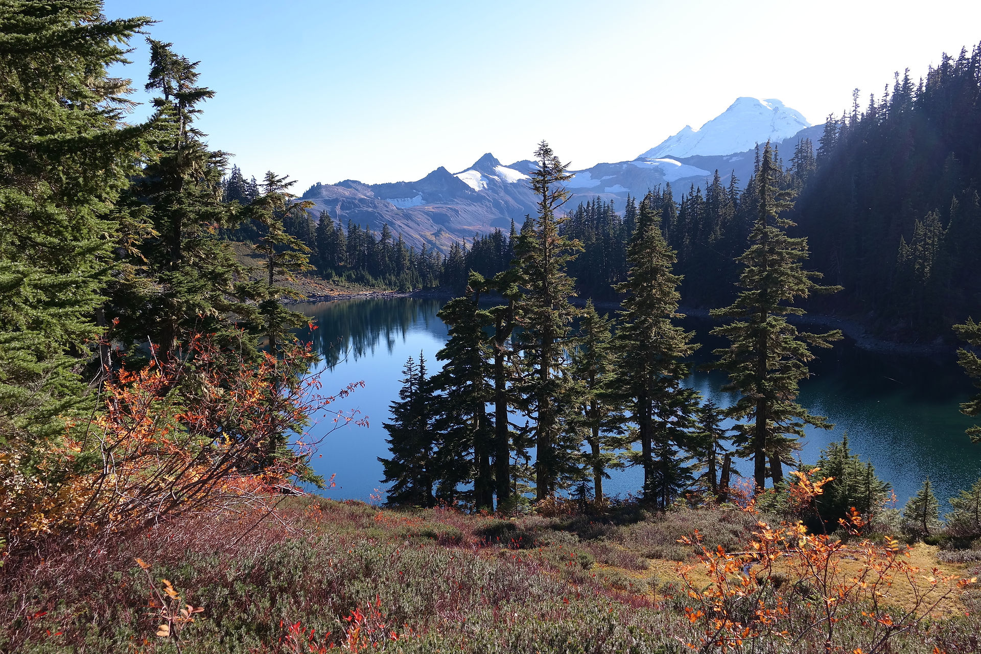
We hit the trail Thursday, 7/23, at around 1:30pm. We only had 3.9 miles to get to Mt. Collins Shelter. Once we pitched tents we experienced “trail magic” from Mother Nature. Not five minutes after setting up our tents, the sky opened up. A torrential downpour for just over an hour. We remained dry. Just before the rain, we were greeted by a friendly deer.

Day two was planned for our long hike, right around 15.6 miles, from Mt. Collins Shelter to Pecks Corner shelter. This day went according to plan. Though the terrain was mostly descending, 15.6 miles on the AT in North Carolina is no joke. We had some tired legs at the end of the day.
One of our hiking friends, Elizabeth, started at Newfound Gap and walked toward me and Andy as we were descending from Mt. Collins. Elizabeth hiked with us back to Newfound Gap. It was nice to have her along for an hour or two.

We spent an unplanned lunch at Ice Water Shelter on day two. We were going to stop for water only, but once again Mother Nature had plans, providing us with another torrent of rain. We had arrived five minutes earlier. More trail magic from nature.
Unfortunately, Andy needed to use the privy, and he got stuck in there when the rain began. He did not make it back to the shelter for over 20 minutes. By the time he returned it was full of day hikers. This shelter is close to Newfound Gap, and this is a popular day-hike route up to the Charlies Bunion viewpoint.
That evening at Pecks Corner shelter we learned from other hikers about the closure of Cosby Knob Shelter due to aggressive bear activity. Our plan for day three was just at 13 miles. We adjusted for a 16.1 mile hike, opting to go beyond the shelter.

During our first night at Mt. Collins we met Maximus and Gunnslinger, two hikers who had started at Springer Mtn in Georgia. We met up with them again on night two at Pecks Corner, so for night three we all planned to camp together again. This is part of what makes the AT magical. Meeting other hikers with the same passion for being out in nature.
On the evening of day three, Saturday, we lucked out with a nice campsite just to the side of the trail, approximately 0.1 miles south of the intersection of Cammerer trail and the AT. Our campsite find was lucky because this was ridge-line hiking. There had been nowhere to pitch a tent for the previous mile. To add to our fatigue, we had watered up at Cosby Knob, our original campsite destination. We hauled over 3 liters of water up a mountain, nearly 3 miles beyond the shelter.
16.1 miles, from 7:30am to 4:00pm. We were tired. But we were not done. Up to this point of the section hike we had not been afforded many views due to the weather. Soon after pitching our tents and finishing dinner, the skies cleared. We were ¾ of a mile from Cammerer fire tower. We grabbed our hiking sticks, and off we went. Worth the effort!

We were joined by Maximus and Gunnslinger, who had found another campsite closer to the tower. It seems we were always on the same page as those two. They were also similar to us in personality. Like me, Maximus likes to talk. Like Andy, Gunnslinger was a bit more reserved.
After many pictures at Cammerer, we all promised to hike back in the dark, the next morning, for the sunrise.
Sunday morning at 5:47am, I hear Andy, “Jerry, do you want to go see the sunrise?”
Our plan had been to wake up at 5:00am. It was a fitful night of sleep for me. Once I finally fell asleep, just after 1:00am, there was little chance I would wake up by 5:00am.
I was not about to be responsible for Andy missing that sunset. Within 24 minutes, by 6:11am, I was packed and walking the trail. I do not intend to break this record for getting ready from a dead sleep.
We arrived at the fire tower with only minutes to spare, witnessing an incredible sunrise. I immediately brewed my coffee and took in the view.


Day four was a pleasant hike downhill to Davenport Gap. We had parked at Big Creek Ranger Station for the safety of our vehicles, so we finished with a 1.5 mile walk on the road after exiting the trail. Only 8 miles total on the last day.
I enjoyed this section. Much more so than the one in 2017 (Fontana to Clingmans). The ascents on this section were much less grueling, and the opportunities for scenic views were vastly more abundant. We hiked in the rain a bit on Friday and Saturday, but that is simply part of hiking in the Smoky Mountains.
My lesson from this section. Water management. On day one I carried too much water considering the shelter, with a water source, was only a 3.9 mile hike. On day three, I probably did not fill quite enough to dry camp. It was a tough climb, and I had just enough. But having just enough water is cutting it close. Despite my fatigue, I should have loaded up a bit more water for that final climb.
Continuing lesson. Total backpack weight. I stepped out on day one at 36 pounds. I’ve been working to reduce my total pack weight. I’m okay with 36 total pounds for 3 nights, but there are still some things I can do to get it down below 30 pounds.
I set three personal records. A 39-mile section is my longest on the AT, and 17.5 total miles hiking is the most I've done in a single day. And, 45 total miles in 70 hours is another one. You are darn right I'm counting the side trails.


Comments